Volume and Mass Balance of Himalayan Glaciers
| ✅ Paper Type: Free Essay | ✅ Subject: Geography |
| ✅ Wordcount: 2692 words | ✅ Published: 19 Oct 2021 |
Why are the volume and mass balance of Himalayan glaciers so poorly known despite their clear importance as water reservoirs to so many people?
Introduction
Within Earth’s cryospheric water towers valuable freshwater resources are stored in the form of snow, permafrost, natural lakes and most notably: glaciers (Bolch et al., 2012). Glaciers influence the hydrological balance of water systems, with increasing meltwater released during the warmer seasons of the year from summer to early autumn (Bolch et al., 2012). Many river systems are birthed and sustained by the influx of this seasonal glacial meltwater. The region of the world where glacial meltwater is critically relied upon by physical systems and human populations is from the third most extensive glaciated region on Earth: The Himalaya.
This essay will firstly highlight the role of physical glacier measurements contribution to glacial data with a focus on the ground-penetrating radar (GPR) technique paired with analysing the restrictions of a sole reliance upon physical measurements. This leads the essay to discuss the effectiveness and reliability of alternative techniques in modelling, remote sensing and current research which have contributed to why mass balance and ice volume in the Himalayan region is ‘poorly’ understood.
Importance
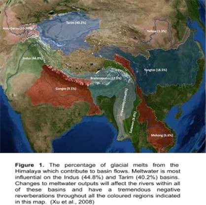
The Himalaya covers an incredible 37,000km² (Bohra, 2016). Its large expanse is coupled with extreme topographic variations and subsequent unique climatic conditions (Bolch et al., 2012). This substantial spatial variability produces a large range of meltwater regimes to regions shown in Figure 1. Consequently, they are not subjected to uniform conditions and so accordingly demonstrate inhomogeneous volumes and mass balances (Bolch et al., 2012). In totality, it is estimated that 800 million people have a dependance on glacial meltwater and severe alterations in seasonal meltwater flow would severely impact an innumerable range of activities from domestic uses such as drinking water to industrial uses of irrigation and hydropower generation (Bolch et al., 2012; Chandrasekharan et al., 2018). This necessitates the importance of data collection methods and estimation approaches that will allow for accurate assessments of volume and mass balance data for all Himalayan glaciers.
Historically, glaciers have been studied individually through direct geophysical methods which provide detailed data yet have a restricted spatial scale (Bahr, Meier and Peckham, 1997). Despite the accuracy of in-situ measurements, the rugged terrain and harsh weather of the Himalaya renders it impossible for all of the glaciers in the Himalaya to be continually analysed through ground-based surveys (Bolch et al., 2012). Inaccessibility has a subsequent knock-on effect on the quantity and quality of mass balance and volume data that are available. An increase in data for the area would contribute not only to the glaciological database for the Himalaya but allow for better calibration and validation of glacier estimating models which would result in more precise and accurate estimation of ice volume and mass balance in the Himalaya.
As a result, mass balance and volume of glaciers in the region have not been rigorously documented and in some publications, unfortunately, misunderstood. Prior errors in the knowledge of mass balance and volume data in the region are being corrected such as the erroneously published statement by Matsuo et al (2010) that the high mountains of Asia have a mass loss of 47-55 Gt yr(-1). This was corrected to a mass loss of only 4 ± 20 Gt yr(-1) for 2003-2010 (Jacob et al., 2012; Matsuo et al., 2010; Dyurgerov, 2010). Such statements are not limited to Matsuo et al. (2010), many inaccurate predictions of the Himalaya have been published, including statements from the IPCC (Boltch, 2012; Scherler, Bookhagen and Strecker, 2011).
Ground Penetrating Radar (GPR)
GPR is a well-established geophysical technique which uses measurements of radio wave pulses reflecting off subsurface inhomogeneities which are detected by a receiver to deduce a GPR profile of the glacial subsurface as shown in Figure 2 (Mishra et al., 2018). It has been used to measure the glacial parameters of volume (Mishra et al., 2018).
The GPR technique has been criticised as a laborious method and for its limited capacity of only being able to measure a single glacier at each time (Huss and Farinotti, 2012). Resolution of GPR readings is governed by the quality of the antenna frequency and the penetration depth. The antenna frequency must be sufficient enough as the penetration depth of readings is strongly decreased by a glacier with high volumes of subglacial meltwater which results in signal attenuation (Mishra et al., 2018). Further to this, the debris present in high debris-covered glaciers such as the Satopanth Glacier in the Central Himalaya acts as a disruptive reflector and enhances scattering and attenuation of the signals as seen in Figure 3. (Mishra et al., 2018).

Misha et al. (2018) studied Satopanth Glacier using GPR methods. The study was unsuccessful as a result of the thick supra-glacial debris cover on the temperate glacier and its high moisture levels (Misha, 2018). Of the twenty-five transects in the study, only two of them were able to receive reflections to assemble a GPR profile (Misha, 2018). The GPR method has significant restrictions and is dependant on uncontrollable physical aspects of the glacier to be able to succeed. This is why alternative geodetic and remote sensing methods must be used to generate a better understanding of ice volume (Singh, Kumar and Dimri, 2018).
Modelling Ice Volume
Due to the deficiency of observational data, there is a need for a theoretical or modelling techniques that predict with tangible reliability and do not overestimate (or underestimate) ice volume or mass balance.
Estimating glacier volume has been done via the volume-area method, slope-dependant ice thickness estimations and an assortment of spatially distributed ice-thickness models (Sattar, 2019). The downside of these methods being that areas of meagre glaciological data coverage rely upon extrapolations from areas with good data coverage (Huss and Farinotti, 2012). With the advent of the Randolph Glacier Inventory (RGI) published in 2012 extreme extrapolation is no longer necessary as the inventory provided a data set of global glacier coverage (Frey et al., 2014; Pfeffer et al., 2014). Yet, as highlighted by Bolch et al. (2012), despite studies using the RGI, estimates of the Himalayan ice volumes were still not unanimous and ranged from 2300 to 6500 km3 (Frey et al., 2014). Contributions to the variable estimations are a result not only of the ±10-20m elevation uncertainty within the RGI digital elevation models (DEMs) but also the absence of a standardised method to determine glacier volume from a singular defined dataset (Huss and Farinotti, 2012). This results in a non-comprehensive understanding of glacier mass balance and volume.
Sattal et al (2019) is one of the studies that have used area-based scaling and velocity-slope based modelling. In the velocity-slope based model, the ice thickness was calculated using surface velocity defined by satellite imagery and slope calculation with ASTER global DEM. This modelling technique allowed for the determination of glacier thickness over a broad range of glaciers with the average ice thickness ranging from 17-92m (Frey et at., 2014). These techniques still held limitations as estimations made through area-based scaling resulted in glacier ice volumes being overestimated as Figure 4 demonstrates (Frey et al., 2014). Overestimation was found particularly prominent in the larger glaciers (Sattar, 2019). To counter this, Chen and Ohmura (1990) suggested the estimation of glacier volume on glaciers larger than 20km2n eeds to be done individually to avoid the exponential increase of volume error with increasing glacier area.

In February 2019 Farinotti et al. (2019) provided estimates for the total volume of ice in the Himalayan region and concluded that previous calculations of ice volume in the Himalaya have been overestimated. Five numerical models were used to calculate the ice thickness with data input from satellite images which determined the glacier outlines and DEMs (Farinotti et al., 2019). These were merged with glacial flow data which resulted in the inference of the spatial distribution of the ice thickness (Farinotti et al., 2019). In regards to the calibration of the models, known glacier ice thicknesses of approximately 1,000 glaciers were used and the uncertainty of the future climate changes were accounted for by different climate model outputs (Farinotti et al., 2019)
Their calculations have predicted that the Himalayan ice volume is 27% less than preceding studies had communicated (Farinotti et al., 2019). This difference will have an effect upon meltwater fluxes and in the long term glacial meltwater output will run dry earlier than predicted. The addition of the research by Farinotti et al (2019) is an important step in securing understanding of glacial ice volume in the Himalaya and perhaps an indication of a closing knowledge gap that can no longer be labelled ‘poorly known’.
Remote Sensing
Due to the impracticalities of accessibility, remote sensing has been crucial to helping bridge the gap with its synoptic remote coverage (Chandrasekharan et al., 2018). The mechanisms available through remote sensing have been able to ascertain both direct and indirect indicators which influence ice volume changes and mass balance changes. For example the determination of mass balance changes are monitored through proxy indicators such as equilibrium-line altitude and accumulation-area ratio which can be observed through remote sensing and methods using DEMs to be able to quantify volumetric changes which in turn is used to understand mass change by using the density values of the ice (Chandrasekharan et al., 2018).
ICESat altimetry measurements have been used to determine elevation changes needed to deduce glacier mass balance variations. However, measurements by ICESat and satellites with similar missions are limited by their ability of spatial coverage of their swath (Bandyopadhyay et al, 2018). The large swath of these global satellites has resulted in the extrapolation of data over the Himalayan region which can lead to underestimations of mass changes in Himalayan glaciers (Chandrasekharan et al., 2018). Further to this, DEMs are only capable of resulting in mass balance calculations on a temporal resolution of 5-10 years (Bandyopadhyay et al, 2018; Chandrasekharan et al., 2018). Their failure is their inability to capture seasonal or interannual changes that could contribute to their observations of current meltwater release or shorter projections of seasonal variability as well as the long term variability (Chandrasekharan et al., 2018).
This is why synthetic aperture radar (SAR) is the preferred method as it possesses a higher spatial coverage (Bandyopadhyay et al, 2018). The aim of the SAR TanDEM-X-mission launched in 2010 was to obtain 3D imaging of the Earth, covering the Himalayan region, which would provide high precision, high-resolution data as elevations were measured within ± 1m. SAR is preferred due to its all-weather and all-day imaging capacity’ (Bandyopadhyay et al, 2018). This feature is particularly relevant in the Himalaya as the Himalaya covers tropical regions influenced by monsoons and high cloud cover, therefore, SAR would facilitate the constant monitoring of glaciers. To better understand Himalayan glaciers in terms of their mass balance, SAR techniques should be encouraged.
Scale importance
A method to measure mass balance using area accumulation ratio/equilibrium line altitude was proposed by Kulkarni et al (2004) for Himalayan glaciers. Yet a problem with their proposed method is a recurring one throughout many other studies: its unscalability over a larger region. This is because the mass balance and accumulation area ratios are not unanimous for every glacier (Chandrasekharan et al., 2018). Debris cover and the heterogeneity of climate throughout the Himalaya region vary thus explaining why it is not possible to use data from a handful of glaciers to extrapolate over the entire Himalaya (Chandrasekharan et al., 2018).
This is why a reflection on scale is important to highlight factors which have resulted in the poor understanding of the region. Previous studies on the Himalayan glaciers have been too narrow (focusing on one sole glacier) and the results of volume and mass balance extrapolated throughout the entire Himalayan range (Bandyopadhyay et al, 2018). On the other hand, studies that have focused on the entire range have resulted in coarse resolution and generalised evaluations (Bandyopadhyay et al, 2018).
Conclusion
The importance of attaining methods and techniques that will lead to the accurate estimation of volume and mass balance in the Himalayan range is of critical importance due to the urgency of being able to strategically manage and predict the freshwater reserves of the Himalaya in the coming years. The rugged terrain coupled with poor application of models over an insufficient or too broad a scale or generalisation through extrapolation has only served to widen the knowledge gap leading to inaccuracies in mass balance and volume.
To truly grasp a comprehensive view of volume and mass balance of glaciers in the Himalaya there must be a cumulation of: continual increase of glacial observations through geophysical methods such as GPR to be able to better calibrate models and to understand inter-seasonal changes; high accuracy of DEMs to predict mass balance changes to the nearest meter; suitable satellite coverage and an acknowledgement that Himalayan glaciers are unique due to debris cover variations, regional localities and heterogeneous responses.
Modelling techniques such as done by Farinotti et at (2019) are paramount to this comprehensive understanding as they are inclusive in their estimation of both remote, understudied glaciers and well-studied glaciers. Learning from past errors, and rerunning models to reflect the changing Himalaya, the complexity of mass balance and volume changes have the potential to be better understood.
References
Bahr, D., Meier, M. and Peckham, S. (1997). The physical basis of glacier volume-area scaling. Journal of Geophysical Research: Solid Earth, 102(B9), pp.20355-20362.
Bandyopadhyay, D., Singh, G. and Kulkarni, A. (2018). Glacier Ice Mass Changes in Central Himalayas During 2000-2004 using TanDEM-X Data. ISPRS – International Archives of the Photogrammetry, Remote Sensing and Spatial Information Sciences, XLII-5, pp.193-196.
Bohra, Archna. (2016). Applications of CRN dating technique with reference to Indian Himalaya- A Compilation. Himalayan Geology. 37 (1) 2016. 54-66,.
Bolch, T., Kulkarni, A., Kaab, A., Huggel, C., Paul, F., Cogley, J., Frey, H., Kargel, J., Fujita, K., Scheel, M., Bajracharya, S. and Stoffel, M. (2012). The State and Fate of Himalayan Glaciers. Science, 336(6079), pp.310-314.
Chandrasekharan, A., Ramsankaran, R., Pandit, A. and Rabatel, A. (2018). Quantification of annual glacier surface mass balance for the Chhota Shigri Glacier, Western Himalayas, India using an Equilibrium-Line Altitude (ELA) based approach. International Journal of Remote Sensing, 39(23), pp.9092-9112.
Chen, J. and Ohmura, A.: Estimation of Alpine glacier water resources and their change since the 1870s, IAHS Publications – Hydrology in Mountainous Regions, I – Hydrological Measurements; the water cycle, Proceedings of two Lausanne Symposia, August 1990, edited by: Lang, H. and Musy, A., IAHS Publ., 193, 127–135, 1990.
Dyurgerov, M. B. (2010). Reanalysis of Glacier Changes: From the IGY to the IPY, 1960-2008. Data of Glaciological Studies, 108: 1-116.
Farinotti, D., Huss, M., Fürst, J., Landmann, J., Machguth, H., Maussion, F. and Pandit, A. (2019). A consensus estimate for the ice thickness distribution of all glaciers on Earth. Nature Geoscience, 12(3), pp.168-173.
Frey, H., Machguth, H., Huss, M., Huggel, C., Bajracharya, S., Bolch, T., Kulkarni, A.,
Linsbauer, A., Salzmann, N. and Stoffel, M. (2014). Estimating the volume of glaciers in the Himalayan and Karakoram region using different methods. The Cryosphere, 8(6), pp.2313-2333.
Huss, M. and Farinotti, D. (2012). Distributed ice thickness and volume of all glaciers around the globe. Journal of Geophysical Research: Earth Surface, 117(F4).
Jacob, T., Wahr, J., Pfeffer, W. and Swenson, S. (2012). Recent contributions of glaciers and ice caps to sea-level rise. Nature, 482(7386), pp.514-518.
Matsuo, K. and Heki, K. (2010). Time-variable ice loss in Asian high mountains from satellite gravimetry. Earth and Planetary Science Letters, 290(1-2), pp.30-36.
Mishra, A., Negi, B., Banerjee, A., Nainwal, H. and Shankar, R. (2018). Estimation of Ice Thickness of the Satopanth Glacier, Central Himalaya Using Ground Penetrating Radar. Current Science, 114(04), p.785.
Pfeffer, W., Arendt, A., Bliss, A., Bolch, T., Cogley, J., Gardner, A., Hagen, J., Hock, R.,
Kaser, G., Kienholz, C., Miles, E., Moholdt, G., Mölg, N., Paul, F., Radić, V., Rastner, P., Raup, B., Rich, J. and Sharp, M. (2014). The Randolph Glacier Inventory: a globally complete inventory of glaciers. Journal of Glaciology, 60(221), pp.537-552.
Sattar, A., Goswami, A., Kulkarni, A. and Das, P. (2019). Glacier-Surface Velocity Derived Ice Volume and Retreat Assessment in the Dhauliganga Basin, Central Himalaya – A Remote Sensing and Modeling Based Approach. Frontiers in Earth Science, 7.
Scherler, D., Bookhagen, B. and Strecker, M. (2011). Spatially variable response of Himalayan glaciers to climate change affected by debris cover. Nature Geoscience, 4(3), pp.156-159.
Singh, S., Kumar, R. and Dimri, A. (2018). Mass Balance Status of Indian Himalayan Glaciers: A Brief Review. Frontiers in Environmental Science, 6.
Xu, J., Grumbine, R.E., Shrestha, A., Eriksson, M., Yang, X., Wang, Y and Wilkes, A. (2008).
The Melting Himalayas: Cascading Effects of Climate Change on Water, Biodiversity, and Livelihoods. Conservation Biology, 23 (3), 520-530
Cite This Work
To export a reference to this article please select a referencing stye below:
Related Services
View all


DMCA / Removal Request
If you are the original writer of this essay and no longer wish to have your work published on UKEssays.com then please click the following link to email our support team:
Request essay removal