Accurate Drainage Network Extraction From Satellite Imagery
| ✅ Paper Type: Free Essay | ✅ Subject: Environmental Studies |
| ✅ Wordcount: 2960 words | ✅ Published: 04 Sep 2017 |
Ferdousi Khatun 1, Pratikshya Sharma1
Computer Science and Engineering Department,
Sikkim Manipal Institute of Technology
Majhitar, Sikkim
Abstract. The extraction of the drainage hydrographical network is a key for various types of study such as hydrological analysis, geomorphology, environmental science, terrain analysis and still a research topic in the field of GIS. Drainage network are extracted through satellite image (e.g. Digital Elevation Model (DEM)) processing, contour map processing and raster map processing. Due to the advances in satellite imagery high resolution DEM are captured by many satellite recently. The DEMs is advantageous over toposheet because it provide consistent data with global coverage. Accurate drainage extraction from DEMs is used for hydrological analysis, morphometric analysis, terrain analysis and many other area as DEM provide the fastest path to extract feature. This paper provides the evolution of satellite imagery and accurate drainage network extraction process for various application namely geomorphometric analysis, hydrologic analysis, terrain analysis etc. also describe the steps involved to extract drainage stream network from DEM an up-to-date process.
Keywords: DEM, ASTER-GDEM, SRTM, Cartosat 1 DEM
1 Introduction
Water is the main and most important component on earth surface and drainage pattern is the essential hydrologic, geomorphologic element for analysis. Drainage pattern is a network that is generally formed by the waterbodies, lakes, streams, and rivers in a particular drainage basin which is also known as drainage system or river system. It has many application area like hydrologic modelling of micro watershed, groundwater prospect zone mapping, geomorphometric parameter analysis, water resource planning and management, flood hazard prediction and mitigation, river pattern change detection ,irrigation management etc. field. But drainage pattern extraction on flat surface and less complex terrain is still in research topic. The traditional process of generating the drainage map is from toposheet or contour map that depict the large scale detail of a geographic space. Generally it contains five layer of information, river and waterbody as blue color, road as red, forest as green, contour as brown and a black color for text feature. However, channel networks extraction from topo maps require tedious time, and cartography expert needed to provide subjective decision. In brief the steps to extract drainage from contour map is aerial element removal, linear element extraction to produce linear feature map, thinning, dilation, color segmentation and generate segmented layer map [1]. But generation of separate layer map has a limitation it will only work on digital contour map or historical map or high quality toposheet because poor quality toposheet suffer from false color aliasing and mixed color problem. Also available toposheet are old publication 10-20 years back. River pattern also change their position in some places due to landslide, flood or many natural phenomena’s thus accurate drainage network is not provided by toposheet [2]. The satellites are capable of producing advanced digital elevation data(e.g., Shuttle Radar Topographic Mission -SRTM-, Interferometric Synthetic Aperture Radar for Elevation -IFSARE-) , Advanced Spaceborne Thermal Emission and Reflection Radiometer Global Digital Elevation Model(ASTER GDEM V2), Cartosat -1 (Cartosat DEM 1.0), Synthetic Aperture Radar(SAR) etc. so analysis became easier. Early satellite technology does not able to capture the DEM directly so for hydrologic and geomorphologic analysis DEM was generated from various satellite like QUICK BIRD,IKONOS, Landsat tm etc.[3].The most widely used satellite imagery ASTER-GDEM,SRTM-DEM etc. are freely provided by USGS(http://earthexplorer.usgs.gov/) site with 1,3 arc second spatial resolution and Cartosat-DEM is provided by ISRO(http://bhuvan.nrsc.gov.in/bhuvan_links.php) and used for analyzing the data for various study. The above mention satellite has their specific configuration and suitable for either mountain area, flat surface, medium complex terrain area for accurate river network extraction. The accuracy of ASTER GDEM SRTM -DEM and is almost same [4]. In some cases Cartosat 1 DEM better sound than SRTM DEM for extracting drainage. DEMs with higher resolution provide detailed drainage networks that has greater impact on the drainage map analysis as statistical values become lower when resolution of DEM changes from fine to rude [5].
1.1 Evaluation of Satellite Imagery for Drainage Extraction
DEM plays a crucial role for generating drainage network. In past years the DEMs were available at a global coverage in a 1 KM resolution like GTOPO-30(Global Topography in 30 arc sec).After that Shuttle SRTM ,version 4,C-band DEM of 90m resolution and the ASTER (version 2, 30 m resolution) was launched that provide better resolution which solves the problem regarding spatial resolution. The hydrology analysis became easier in INDIA after launch of Cartosat DEM (version 1) at 30 m in 2011.These data are openly accessible and easily downloaded from USGS and ISRO website. Various purchased stereo-images from Cartosat 1,landsat 7 ETM+,QuickBird,IKONOS,SPOT,SAR are used for generating the DEM using software and can be applied for hydrologic analysis[6],[7],[8],[9][10].Lot of studies is going on hydrological analysis and geomorphometric analysis from DEMs. In India most research is done best on DEM for river basin analysis, estimation of soil loss, water resource evaluation and topographic characterization[11],[12],[13],[14].The high resolution DEMs provide finer extraction of land surface component like drainage network, slope facets and higher accuracy than a toposheet.The morphometric parameter are heavily depend upon the scale of the feature extrcated.Research is going on which satellite provided imagery is relevant for accurately extract the stream network in various surface area like mountain, flat surface, less complex terrain area.In some cases SRTM is very good for drainage analysis[15],[16]. For accuracy assessment the complete elevation criterion is more focused and less importance given to how the various morphometric variables that are derived, vary from one dataset to the other, as well as how their prepared maps differ.
1.2 Importance of Drainage Network in GIS
Drainage means the deportation of surplus water from a given place. In geomorphology and hydrology a Drainage pattern is a network that is generally formed by the waterbodies, lakes, streams, and rivers in a particular drainage basin. They are depend on topography of the land. The shape, size, number of the drainage basins found in an area vary with the topography. A drainage system are of six different type namely Dendritic Drainage, Parallel Drainage, Trellis Drainage, Radial Drainage, and Rectangular Drainage and Deranged Drainage. In hydrological studies, geomorphological analysis DEMs are primary element for catchment boundary, delineation of watershed boundary, estimation of various catchment parameters such as slope, contours, aspects, etc. and morphometric attribute like no of tributaries, stream order, stream length, bifurcation ratio, relief ratio etc. By examining various hydrological and morphological parameter the irrigation management department supply water in dry weather for agriculture crop production, water resource management department, flood hazard zone prediction and mitigation department, drainage management department are being very beneficial in recent year.
1.3 Review of Drainage Extraction Methods
The mesh network of attached stream pertaining to a land is the river pattern or drainage pattern. These network formation is mainly depend on the morphological aspect of the terrain i.e. slope, varied resistance of rocks and geology and topology of the land. When a DEM is consider for drainage network extraction, the main steps are (1)fill depression,(2)flow direction,(3)flow accumulation and (4)stream network generation. A DEM is the representation of land elevation in digital form that are
mainly stored as a rectangular matrix with integer or floating-point values. Among various algorithm the DEM pixels computation is based on D8 method that is first introduced by O’Callaghan and Mark (1984)[17].But this algorithm has some derelictions. As per D8 algorithm single flow direction is calculated by comparing the elevation of its 8 neighboring cells where the cells with higher elevations flow towards adjacent cells with lower elevation as the water flow from high elevation to low due to gravity. However parallel flow lines generation in flat areas is the restriction of formation of concentrated channel flow and is a vital limitation of D8 method. The most important problem while delineating stream network using DEM is the presence of sinks, for flat area and depressions it is difficult to set the ends of stream network and the flow direction assignment in individual cells. Thus for accurate extraction the sinks are removed from DEM in the first step. In 1988 an new developed algorithm is introduced by Jensen and Domingue to remove the sinks prior to the flow directions calculation by increasing the elevation value of nodes within each depression pixel to the level of the lowest node on the depression boundary. Next A new method to calculate the upslope areas using rectangular grid DEM and representation of flow directions is introduced known as D-infinity where the direction of flow is not restricted to check its 8 adjacent cells[18].Some research is also done based on multipath flow direction but it is time consuming and more manual effort required for calculation[19][20].To improve the existing method a path based methods to resolve the nondispersive drainage flow direction in grid based DEM is introduced. It improved the D8 a few extent but fails to eliminate local level bias [21]. Over the past 20 years, many improved method based on routing flow through pits and flats have been introduced. The technology developed and the drainage is extracted based on heuristic information. An innovative algorithm is presented by W. Yang and co -authors in 2010 based on heuristic information that accurate extract the drainage network but fails to detect unrealistic parallel drainage lines, unreal drainage lines and spurious terrain features and has a closer match with the existing pattern [22]. More recently in 2012 Mr.Magalhaes have proposed a very simple and innovative approach where the DEM is considered as island and the outside water level raises step by step until the whole DEM is submerged. So gradually it flood the cells of the DEM, next filling the depression and spread it on flat to flow towards a neighbor if that neighbor has a assigned direction of flow that does not point back to the early visited cell. In such manner, the flow direction assignments grow iteratively into flat surfaces from areas. After that flow direction is calculated and accumulation flow is generated that is the final step of stream network generation or drainage network computation [23].In 2013 a flooding algorithm is proposed by Antonio et.al to extract the drainage on flat surface and able to works on unprocessed DEMs avoiding the problems caused by flats and pits, able to extract watercourses with a width greater than one cell and identify fluvial landforms such as marshes, lakes or river islands that are not directly managed by most of previous solutions[24].
1.4 Literature Survey
Research is going on which satellite imagery provide the accurate result for drainage extraction. DEMs provide us a digital representation of the continuous land surface. Advanced remote sensing technologies (e.g. SRTM, ASTER-GDEM, Cartosat 1.DEM etc.) are capable of generating new elevation data and freely availbale.High resolution DEM provide accurate drainage extraction. During past 20 years many satellite generated imagery is used to extract the drainage pattern and examined on various terrain like mountain area, medium complex terrain and flat surface. But the accurate extraction which is very essential for hydrologic and morphological analysis is still lacking some feature.Gajalakshmi K. and Anantharama V. recently analyses the accuracy between Cartosat 1 DEM and SRTM DEM.As per experiment in gradually undulating terrain, elevation values of Cartosat-DEM are lower than SRTM-DEM. whereas the stream parameter values of Cartosat-DEM are higher than SRTM-DEM[25]. Sarra Ouerghi et.al. comparers the ASTER-GDEM and SRTM DEM for drainage extraction. The analysis found that ASTER GDEM is more pronounced in flat and less complex terrain [26]. Sample drainage network represented in fig 1.4.
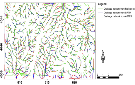
Fig 1.4. Stream networks derived from Topo DEM, ASTER GDEM, and SRTM [26]
Table 1. Summary of Survey
|
SL No |
Title |
Description |
Remarks |
|
1 |
Water Body Detection and Delineation with Landsat 5 TM Data. |
Landsat 5 TM + imagery used to map river line waterbody and compared with Aerial image. |
Manual classification of Landsat imagery and Aerial imagery. Error in image registration occur. |
|
2 |
DSM generation and evaluation from QuickBird stereo imagery with 3D physical modeling. |
QuickBird stereo imagery is used for generating the DEM and 5m contour generation and drainage pattern extraction. |
Manual process to prepare DEM Automatic extraction missing. Resolution high but time consuming process. |
|
3 |
Cartosat-1 derived DEM (CartoDEM)towards Parameter Estimation of Microwatershed and Comparison with ALTM DEM. |
Cartosat-1 and ALTM DEM is compared for drainage pattern extraction and Microwatersheds parameter analysis in MadhyaPrades. |
Suitable for Mountain area but not suitable for plain area.Saveral steps required to process the DEM and extract the data. |
|
4 |
Assessment of extraction drainage pattern from topographic maps based on photogrammetry |
Aerial Image and four toposheet is processed for drainage mapping and compare the both. |
Satellite imagery accurately extract drainage, some drainage is missing in toposheet. Several image processing steps required to extract pattern from satellite image. |
|
5 |
A GIS based approach in drainage morphometric analysis of Kanhar River Basin, India. |
ASTER-DEM,Landsat ETM+,SOI toposheet for morphometric analysis |
All morphometric parameter has not been introduced. |
2. Conclusion
The extraction of drainage networks can be done form of contour map, raster map or DEMs.The satellite provided DEMs are very efficient to extract the drainage network in all terrain because the satellite gives the up-to-date changes happen on earth surface like change position of river network, new waterbody etc. feature is capture via highly sensitive sensor present in satellite. Thus less time required to extract the pattern from satellite provided DEM.Survey found that automatic extraction is accurately extract the pattern rather than topographic map with less error. The Cartosat 1 DEM is very useful for mountain area, SRTM and ASTER-GDEM is suitable for medium and flat surface where terrain is less complex.
References:
- Tiange Liu & Qiguang Miao & Pengfei Xu & Jianfeng Song & Yining Quan. : Color topographical map segmentation Algorithm based on linear element eatures. Springer Journal,Multimedia Tools and Application, Volume 75, Issue 10, (2016)5417-5438
- Samih B. Al Rawashdeh. : Assessment of extraction drainage pattern from topographic maps based on photogrammetry. Springer, Arabian Journal of Geosciences , Volume 6, Issue 12, (2013) 4873-4880
- T. Toutin. : DSM generation and evaluation from QuickBird stereo imagery with 3D physical modelling. International Journal of Remote Sensing, VOL. 25, NO. 22, (2004)5181-5193
- Sarra Ouerghi, Ranya Fadlalla Abdalla ELsheikh, Hammadi Achour, Samir Bouazi : Evaluation and Validation of Recent Freely-Available ASTER-GDEM V.2, SRTM V.4.1 and the DEM Derived from Topographical Map over SW Grombalia (Test Area) in North East of Tunisia. Springer Paper, Journal of Geographic Information System, 7, (2015) 266-279
- Gajalakshmi K. and Anantharama V. : Comparative Study of Cartosat-DEM and SRTM-DEM on Elevation Data and Terrain Elements. Cloud Publications International Journal of Advanced Remote Sensing and GIS. Volume 4, Issue 1, (2015) 1361-1366
- Toutin T, Chenier R, Carbonneau Y 3D geometric modelling of Ikonos Geo images. In: Proceedings of ISPRS joint workshop .High resolution from Space”, Hannover(2001).
- Toutin T.: DEM from stereo Landsat 7 ETM+ data over high relief areas. Int J Remote Sens 23(10) (2002)2133-2139
- Toutin T. : DSM generation and evaluation from QuickBird stereo imagery with 3D physical modelling. Int J Remote Sens 25(22) (2004)5181-5192.
- Poli D, Li Z, Gruen. : A SPOT-5/HRS stereo images orientation and automated DSM generation. Int Arch Photogramm Remote Sens 35(B1) (2002)130-135
- Hirano A, Welch R, Lang H.: Mapping from ASTER stereo image data: DEM validation and accuracy assessment. ISPRS J Photogramm Remote Sens 57 (2003)356-370
- Chopra R, Dhiman RD, Sharma PK.: Morphometric analysis of subwatersheds in Gurdaspur District Punjab using remote sensing and GIS techniques. J Indian Soc Remote Sens 33 (2005)531-539.
- Kale VS, Shejwalkar N.: Western Ghat escarpment evolution in the Deccan Basalt Province: geomorphic observations based on DEM analysis. J Geol Soc India 70 (2007)459-473.
- Sreedevi PD, Owais S, Khan HH, Ahmed S.: Morphometric analysis of a watershed of South India using SRTM Data and GIS. J Geol Soc India 73 (2009) 543-552
- Ghosh P, Sinha S, Misra A.: Morphometric properties of the trans-Himalayan river catchments: clues towards a relative chronology of orogenwide drainage integration. Geomorphology 233 (2015) 127-141
- Gorokhovich Y, Voustianiouk A.: Accuracy assessment of the processed- SRTM based elevation data by CGIAR using field data from USA and Thailand and its relation to the terrain characteristics. Remote Sens Environ 104 (2006) 409-415
- Weydahl DJ, Sagstuen J, Dick OB, Ronning H.: SRTM DEM accuracy over vegetated areas in Norway. Int J Remote Sens 28(16) (2007) 3513-3527
- O’Callaghan J, Mark DM.: The extraction of drainage networks from digital elevation data. Compute Vis Graph Image Process 28(3) (1984) 323-344
- David G. Tarboron.: A new method for the determination of flow directions and upslope areas in grid digital elevation models”, WATER RESOURCES RESEARCH, VOL. 33, NO. 2, (1997) 309-319
- Zhang Yu, Liu Yong-xue, Chen Zhen-jie. : Multi-flow direction algorithms for extraction drainage network based on digital elevation model. Geospatial Information Science, 6753(2B) (2007) 1-9
- Tarboton D G. : A new method for the determination of flow directions and upslope areas in grid digital elevation models [J]. Water Resources Research, , 33(2) (1997) 309-319
- Orlandini S, Moretti G, Franchini M, Aldighieri B, Testa B. : Path- based methods for the determination of nondispersive drainage directions in grid-based digital elevation models. Water Resour Res 39(6) (2003)
- W. Yang1,2, K. Hou1,3, F. Yu2 , Z. Liu4 , and T. Sun1. : A novel algorithm with heuristic information for extracting drainage networks from raster DEMs”, Hydrol. Earth Syst. Sci. Discuss., 7, (2010) 441-459
- Magalhaes, S.V.G., Andrade, M.V.A., Franklin, W.R., Pena, G.C. : A new method for computing the drainage network based on raising the level of an ocean surrounding the terrain, in: Proceedings of 15th AGILE International Conference on Geographic Information Science, Avignon (France), (2012) 391-407
- Antonio Rueda , José M. Noguera , Carmen Martínez-Cruz.: A flooding algorithm for extracting drainage networks from unprocessed digital elevation models. Computers & Geosciences Volume 59, (2013) 116-123
- Gajalakshmi K. and Anantharama V.: Comparative Study of Cartosat-DEM and SRTM-DEM on Elevation Data and Terrain Elements. International Journal of Advanced Remote Sensing and GIS, Volume 4, Issue 1, (2015) 1361-1366
- Sarra Ouerghi, Ranya Fadlalla Abdalla ELsheikh, Hammadi Achour, Samir Bouazi.: Evaluation and Validation of Recent Freely-Available ASTER-GDEM V.2, SRTM V.4.1 and the DEM Derived from Topographical Map over SW Grombalia (Test Area) in North East of Tunisia.Journal of Geographic Information System, 7, (2015) 266-279
Cite This Work
To export a reference to this article please select a referencing stye below:
Related Services
View all


DMCA / Removal Request
If you are the original writer of this essay and no longer wish to have your work published on UKEssays.com then please click the following link to email our support team:
Request essay removal